Tuesday, May 29, 2012

Max Patch

Max Patch is well worth the 3 hour trip from Charlotte, NC. To get there take I-85 South to US-74 West to I-40 West to exit 7 at Harmon's Den Rd. Then go 6 miles up a passable dirt road to the Max Patch parking lot. The trail to the left is a nice gradual ascent to the top of the bald. Once at the top of this 4616' bald, the spectacular 360' views just smacks you in the face. The weather was clear blue skies in the 80's with a slight breeze blowing across the meadows of wildflowers. After taking it all in and carrying a full pack I connected onto the Appalachian Trail heading toward the forest edge about 300 yards down the backside of the bald. A perfect campsite only 20' into the woods and 10' cooler. With camp all set up I head down the AT to the shelter (1.5 miles) and back. Mesquite chicken, black beans, and rice wraps for dinner. I hiked back to the top of the bald to watch a beautiful sunset and a picturesque starlit sky. The night brought out the fireflies and barn owls. A firefly was lighting up my tent while an extremely close barn owl hooting up a conversation with a distance friend. Surprisingly, after a restless night, I woke up in time to head back up to the top of the bald for a magnificent sunrise. NO PICTURES will do it justice. It's something you will have to experience for yourself to get the full beauty of this place. Throughout the day, Sunday, I watched and talked to several thru-hikers going from Georgia to Maine. The first three individual hikers seem very determined by hiking very quickly. The next two hikers had a much slower pace and stopped at the bald for  a snack. The last thru-hiker I encountered was in absolutely no hurry and was eager to stop and chat with anyone that would take the time to speak to him. His goal for completing the entire AT was 8-12 months. Max Patch started getting hot again so back to the woods for a quick nap. After seeing two tents erected up on top I decided to pack up and move to the top of the hill. But being so hot earlier in the day, Bailey and I drank an excessive amount of water and ended up running out. With no water for cooking dinner or breakfast and hydrating throughout the next day and no water source anywhere nearby, I decided to pack it out. Sometimes you bring too much (e.i. The Art Loeb Trail) and sometimes not enough. I was disappointed not to camp on top of Max Patch but I will return to do just that. And by the way, I suggest camping of top of Max Patch ONLY if it's a clear day and with very little wind. I don't suggest having a fire at anytime on top of the bald. Don't forget to bring your fishing pole to cast in the trout pond just past the parking lot or the hatchery supported stream at the entrance of Harmon's Den Rd.

Hiking up to Max Patch

View from top of Max Patch

Someone balanced rock along the trail

Marker for Max Patch

View right beside camp

View looking down to the valley

30 minutes before sunset

Another great view

"I like it up here"

Just chillin

Sunset

Sunset

Camping on top of the world

Sunrise over my campsite just within the woods

Sunrise

Hiking the AT up to Max Patch 4X

Napping on my therm-a-rest in a grassy patch

"You woke me up"


Tuesday, May 22, 2012

Hanging Dog Campground on Lake Hiawassee

Hanging Dog Recreational Area with such amenities as a campground, picnic area, hiking trails, biking trail, boating, canoeing, fishing, and rafting is located within the Nantahala National Forest just West of Murphy, NC. At the western most tip of NC, Hanging Dog Campground is about 230 mile (4+ hours) from Charlotte. With 69 total campsites on 4 loops, we chose campsites 23 and 24 on Loop B, the only campsites on Lake Hiawassee. By far the best two campsites with a handful of large trees providing adequate shade and easy access to the lake. Lake Hiawassee has almost 188 miles of undeveloped shoreline up against a picturesque mountain backdrop. Wesley and Paul brought their canoe to explore this green mountain lake. I arrived a day later, Friday evening, with Dad sitting around the campfire holding Lilly in his lap. Dad makes a couple of burgers for me while I set up my Half Dome 2 tent. PBR, burgers, campfire, and family, what more do you need? Our nighttime symphony included some loud frogs, crickets, and carp splashing around the vegetation in the shallows of the cove. After an awesome omelette and some bacon from Warren Wilson College, Dad, Owen and I paddled out in the canoe to do some serious fishing. We fished every cove and around every fallen tree near the edge of the banks for about 3 hours until lunchtime. To tally it up, Owen caught a bluegill. I caught two bluegills and a catfish and dad caught two bluegills. Bailey and I headed up the Ramsey Bluff Trail for about a mile until we realized this trail has grown over and very seldom walked. So we turned back after the forest started to swallow the trail and I found three ticks on me and Bailey. The other trail, Mingus Trail, was closed due to a controlled burn. Dinner included an appetizer of fried Bluegills and catfish with a shrimp boil for the entree. Paul needed to get on a plane heading for San Diego for work by Sunday afternoon so everyone got up early, packed up, and went our separate ways home. On the way home I stopped by Nantahala Whitewater Rafting Center to observe a few kayakers maneuvering down the rapids. Overall, Hanging Dog Campground was a nice place to visit and Lake Hiawassee was beautiful but had some trash floating BUT a little too far to travel from Charlotte for a weekend getaway. Especially when there are so many great spots in between.

Campsite # 24

Bluegill

Bluegill

Sunset on Lake Hiawassee

Early Morning Lake Fishing

Wednesday, May 16, 2012

A Day of Fly-Fishing at Davidson River

Taking advantage of coming home (Hendersonville) for Mothers Day I called Dad up for a day of fly-fishing at Davidson River. Surprisingly Dad gets there early so we head out toward Brevard and the entrance to Pisgah National Forest. We find a nice pull-off and get geared up with my new Caddis Deluxe Breathable Chest Waders and Caddis Wading Boots. I start off with a type of stone fly but after observing a few Blue Winged flies being active around the waters I changed to a Blue Winged Olive. Not too familiar with all the various types of dry flies, nymphs, midges and such but I am experienced enough to observe what's flies are active around the stream. Davidson River is indeed one of my favorite places for fly-fishing. The slow flowing currents provides many pools to cast upon. The water was cool and clear with a good flow. Fishing at a slow and steady pace, I wanted to give the trout every opportunity to strike. I lost sight of dad at one point. He had made a quick trip to Arby's to bring back lunch. After our picnic, we fished for another hour or so until time ran out for dad to get back to Sylva. Dad had caught a small rainbow (4") in a nice pool at a bend in the stream. Davidson River is mostly catch and release so he let it go to catch it again another day. I, on the other hand,  didn't catch any trout but did manage to attract a total of 9 ticks crawling on me. Today was a great prelude to Mother's Day.

Dad caught a nice size branch

Fly in the water


Tuesday, May 1, 2012

The Art Loeb Trail is a Beautiful Beast! (Part 1)

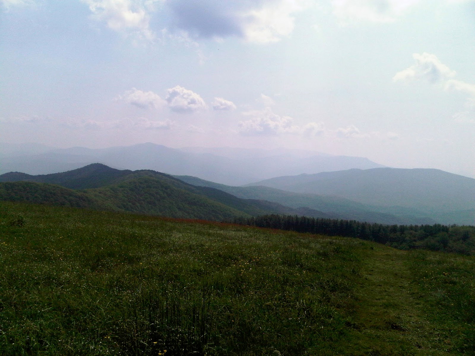
The plan was to leave a little early Thursday and drive to Pisgah National Forest and camp at Davidson River Campground. Leaving our truck there, Mom would pick us up around 8:00am and drive us to the trail head at Daniel Boone Boyscout Camp. But once we got to Asheville the sky dropped down with quarter size hail. So we ended up at my Moms house and headed to the trail head early in the morning. Everyone was filled with anticipation, excitement, and great expectations. After the photo ops, we start blazing the trail straight up 3000 ft in elevation for 3.8 miles to reach Deep Gap. Once we reached the top of Deep Gap some of the anticipation and excitement turned into exhaustion, at least for Cassie (my daughter) and I. At Deep Gap, the trail splits with the trail to the left going up another 1000 or so feet to Cold Mountain and the trail to the right is our trail going through the Narrows and up to Stairs Mountain. Vickie didn't really like the Narrows and all the rock scrambling we had to do. At this point she started making Crow calls. I think to keep her mind off the fact that the side of the trail drops off so steeply. Once we made it to Stairs Mountain, we then realized why this trail is most difficult and the hardest trail in NC. Cassie and I couldn't go any further so we set up camp. The first night everyone went to bed early, about an hour before the sun went down. A coyote called out several times. I was very pleased with my new Half Dome 2 tent. It was very roomy for two. Day 2, we got up around 7:30 and made oatmeal with dried fruit and bagels for breakfast (yes bagels, don't recommend due to the extra weight). Cassie had to have her cheese grits. I love my JetBoil, hot water in 2 minutes. By 8:30 everyone was packed and ready to tackle the trail for another day. Along the Shining Rock Ledge and passing Shining Rock we encountered beds of quartz rocks and a trail through tunnels of forestry and Rhododendrons. At Shining Rock, the trail branches off in several different directions but Matt was on point with the map. Through section 4 and section 3 of the trail we encountered plenty of opportunities for water, ONLY because of the heavy downpour on Thursday. After hiking a pretty long stretch where we tunnel through the forest, the trail opens up into a grassy knob with beautiful 360' views that's breathtaking. Exiting the grassy knob the trail closes around you as fast as it opened. Ascending another mountain and descending again into Ivestor Gap where Shining Rock Wilderness ends and Pisgah National Forest begins. While taking a break and eating some of Vickie's delicious trail mix we came across several groups heading the opposite way. This is the beginning of the most spectacular part of the Art Loeb Trail where you ascend up one peak and up higher to the summit of Tennent Mountain at 6040 ft in elevation. This is where the sun really beats down on you. The view from Tennent Mountain includes Mount Pisgah and Looking Glass Rock. Next the trail travels a mile up a steady slope through head high brush and grassy fields to the Black Balsam Knob. The views here is the just reward for every hard earned step up to this point. Cassie's back has had enough so we called my mother to pick her up from the Art Loeb Spur Trail. She did really well and didn't complain one bit and I love her dearly for going on this adventure with her dad. At this point Matt, Vickie, and I decided to not continue along the Art Loeb Trail but instead explore the Graveyard Fields and camp our second night there. Our decision was solely based on not being able to complete the trail in time, largely because I was sucking wind. We went to the Graveyard Fields parking lot and unloaded a large amount of extras to lighten the load. Matt, Vickie, and I (and Bailey, dog) started down the trail toward the Lower Falls. After seeing the Lower Falls we set up camp in a nice little cove by a creek and started a fire. We tried to hike up to the Upper Falls but no one had it in them. In the morning we hiked out and waited until Mom came to pick us up. On the way home we stopped by Looking Glass Falls.
Even though our plans of completing the Art Loeb Trail didn't pan out, this was still a great trip thanks to Cassie for going with me, Vickie and Matt for going, Bailey for being so good throughout the trip, and Mom for everything she did. We will return to finish section 2 and section 1 soon for Part 2. In conclusion, an absolutely beautiful trail but such a beast!


Total: 14 Miles