Sunday, March 31, 2013

12 Waterfalls in 2 Days!

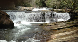
I have a long weekend off for Easter and feeling very eager to get out-n-about. The plan was to head to Hendersonville, pick up my mother, and go see a few waterfalls. My mom has an adventurous spirit when it comes to sightseeing but is a little limited physically when it comes to hiking. The first waterfall we saw was Looking Glass Falls (1) at 65ft. We then stop just up the road at Moore Cove Falls (2) pull-off. Taking our time we cross the wooden foot-bridge over the creek ascending into the woods. The trail is a moderate .7 mile hike to the falls. The Moore Cove Falls is a waterfall that flows from an overhanging rock, forming a cave-like area that allows visitors to walk behind the falls. We then drove over to FS 475B. About 1.1 miles down the forest road is a small pull-off on the right. Go .2 miles up the trail to Slick Rock Falls (3). This 30ft passive flowing waterfall is covered with algae, moss, and lichen, making it true to its' name. FS 475B connects onto FS 475 and down that road is another pull-off across from a gate for the Cove Creek Group Campground. Hike around the gate and down the gravel road for about .6 miles. Look to your right and find an unmarked trail down the bank to the Falls on Cove Creek (4) at 35ft. Continue hiking another .6 miles up the gravel road to a trailhead to Caney Bottoms and an open meadow at the group campground. At the far end of the campground is the Little Sliding Rock Falls (5) at 10ft. We didn't have the energy to hike the additional mile to the 65ft Cove Creek Falls. This one will be added to my to-do list. After hiking back to the car we spotted a trail leading to the waters on the other side of the road. Exploring the trail .1 mile we came across a really nice unknown waterfall. Getting late in the day we head home for dinner and some much needed rest. Day two started about 10:30. The pull-off for Jackson Falls is down  FS 475 about two miles pass the gate for Cove Creek Group Campground. This part of the road is a little rough with many potholes. Glad I drove my truck today and not my mom's car. To get to Jackson Falls (6) we walked down the gravel road, pass an iron bridge, to the Daniel Ridge Loop Trail. Turn right at the fork and Jackson Falls is up the trail on the left side. This is a .8 mile out-n-back hike. This 150ft waterfall is very unique and well worth the trip. We continued down FS 475 until it ran into US 215. Across US 215 was five beautiful waterfalls on one short trail. First check in with the Living Waters Ministries as this is private property. Once you get permission follow the trail behind the building to see French Broad Falls (7) and the Mill Shoal Falls (8). The French Broad Falls is 15ft and the Mill Shoal Falls is 20ft. Follow the trail downstream 100ft or so to an overlook of Rooster Tail Falls (9) and Lower Rooster Tail Falls (10). Rooster Tail Falls is 15ft high and the kicks up like a rooster tail. Lower Rooster Tail Falls is 6ft but much wider. Further downstream is the Bird Rock Falls (11) sitting up against a monumental cliff with a pool at the bottom. Tucked away from everything this scenic waterfall is absolutely spectacular. After taking in these falls and absorbing their beauty we had it in us for just one more sight. So driving up US 215 and we turned onto FS 140. Three miles along FS 140 is the pull-off for Courthouse Falls ( 12). This is a .8 mile damp and rocky out-n-back trail. The Courthouse Falls is a powerful yet tranquil 45ft waterfall. This one is on my list of favorites. We saw a handful of unknown waterfalls throughout our two days as well. Spending the two days with great company (my mother), being outdoors and exploring waterfalls has been an epic Easter weekend.

Moore Cove Falls

Moore Cove Falls

Cave near Moore Cove Falls

Slick Rock Falls

Falls on Cove Creek

Little Sliding Rock

Unknown Falls across from Cove Creek Gate

Jackson Falls

Iron Bridge to Jackson Falls

Davidson River

Trailhead to Caney Bottoms

French Broad Falls

Mill Shoals Fall

Rooster Tail Falls

Lower Rooster Tail Falls

Bird Rock Falls

Rock cliff and pool at base of Bird Rock Falls

Courthouse Falls


Wednesday, March 13, 2013

CONGAREE NATIONAL PARK, SC

A sunny and 65'+ weekend is a calling for me to be outdoors. So, down the road I go. After about 110 miles down I-77, I find the entrance of Congaree National Park. Registering in the Rangers Office for a campsite for the night. Longleaf Campground was completely full for the weekend so my only options were to camp at the Bluff Campground or find a spot in the backcountry. The Bluff Campground was about a mile down the Bluff Trail to an open field with 6 sites. Each site was equipped with a picnic table and a fire ring. Upon setting up my tent and kitchen area ( about 30 minutes time ) the last four available sites were already taken. A beautiful, warm and free weekend brings the crowds outdoors, and all before 10 am. Down the trails I go. Feeling ambitious I charge down the River Trail (10 mile loop) to the Congaree River and back. Along the way one will cross a number of  "guts" or small creeks with cone-shaped cypress trees and water tupelo protruding out of the water. The forest along the river is notably denser then that of other trails with giant cherrybark oak trees scattered throughout the park. Some are covered with Spanish moss dripping off their branches. Woodpeckers are in abundance within the park with echos of hammering filling the air all around you. If you get a chance to look down you'll find deer tracks on top of deer tracks as well as raccoon, bobcat, and wild boar tracks. I saw fresh boar tracks and evidence of boar wallowing in the mud. Cedar Creek flows through the middle of the park and is an excellent pathway for canoes and kayaks. Back at the campsite with rubbery legs I took advantage of the warm sun with a quick nap. Bailey agreed. I woke to a Ranger making his rounds so we chatted awhile. (Side Note: The staff here is very nice and helpful). A lot of dead wood laying around provided a nice pile of firewood for the night. I then tried some survival skills I learned from the show Dual Survival by starting a fire the hard way. With some lent I packed from the dryer at home ( my mothers suggestion ) I lit the lent with ease with a flint stick and the back of my knife. Surprisingly it worked. Now for roasting hotdogs with a sturdy stick over the fire. Clear skies, bright stars, eating roasted hotdogs by the roaring fire with no bugs and some dinner music coming from two campsites over makes for a great end to a good day. Group of scouts two sites over pulls out a guitar and a violin for some low tone dinner music. Checking out the Big Dipper, Little Dipper, Ryans Belt, and the North Star along with the aroma of a flaming fire makes for heavy eye lids. Was that a shooting star? Morning comes an hour early with the Spring forward thing. Breakfast brings hamburger and scramble egg wraps and cooold drinking water. I don't drink coffee. After teeth brushed, face and hair washed, and changing clothes I start packing up my campsite back into my Red Cloud backpack. Check out is at 12 noon. But it is only 10 am so I hike out to the parking lot along the Bluff Trail and load up my truck. Grabbing some water, snacks, and Bailey I head back into the park toward the Weston Lake Loop Trail ( 4.4 miles ) with a side spur trail to Wise Lake. Spring is coming and this was a great way to start.

Before you go and visit Congaree National Park I recommend you call for flooding conditions and the mosquito meter.

Total: 17 miles

Congaree National Park

Fresh Wild Boar Tracks

Cypress Trees and Water Tupelo

Cone-Shaped Cypress Trees

Cedar Creek

Wise Lake

Tracks ?

One of Many Deer Tracks

Sap Dripping from Veins

Massive Pines

Massive Pines

"Gut"

Cedar Creek

Cedar Creek